Recreation
Dam proponents claim that a reservoir at Auburn would provide more and better recreation opportunities for Californians.
Dam proponents claim that a reservoir at Auburn would provide new recreational facilities. The Auburn Dam Council, a major supporter of the Auburn Dam Project states “Recreation plans include camp sites, picnic sites, boat launching ramps and swimming areas.”
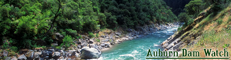
The American River canyons currently support a wide variety of recreational activities.
The mild climate in the Auburn area provides for year-around outdoor exploration. Auburn State Recration Area (ASRA) currently supports more than 900,000 annual visitors enjoying whitewater boating, hiking, trail running, mountain biking, horseback riding, fishing, gold mining, hunting and off-highway vehicle (OHV) use.
In addition, Auburn is proclaimed to be the “Endurance Capital of the World”, hosting a variety of extreme endurance events including the 100 mile Western States Run and the equestrian Tevis Cup Ride.
The Auburn State Recreation Area (ASRA)
The land set aside for the Auburn Dam Project is known as the Auburn State Recreation Area (ASRA) and is managed by the California Department of Parks and Recreation (DPR). ASRA is currently undergoing a planning process to update the Resource Management Plan, this plan will determine how California State Parks will continue to manage recreational use within the take-line of the Auburn Dam. ASRA encompasses 42,000 acres and 48 miles of river corridor along the North and Middle forks of the American River.
In the 1991 American River Water Investigation Report (an Auburn Dam feasibility study) the Army Corps of Engineers stated:
Because of reasonable proximity, accessibility, high scenic quality, regional uniqueness and excellent whitewater, the Upper North and Middle Forks of the American River and surrounding Auburn SRA are a unique and irreplaceable entity to both the growing Sacramento area and Northern California alike.
It is unlikely that a reservoir in Auburn would provide a recreation pool equal to that of the unspoiled canyons.
It is important to understand what a reservoir would do to the canyons, especially a reservoir utilized for flood control purposes. There would be between 100 and 300 feet of water fluctuation each year. Imagine it is late winter or early spring (depending on the year), the water in the reservoir has been drawn down to provide space for the coming rains and snowmelt. The beautiful canyon you once enjoyed is a muddy mess. The distance from the water level to the highwater mark is 300 feet. In this swath of mud and sludge there is no plant life, for it has been drowned. There are no animals, as the riparian ecosystem has been destroyed. The once vibrant canyon has become a storage ditch. If there were no other options for flood control, water supply and power generation, this devastation could be rationalized. Fortunately, we have options – viable options that are sustainable.